Translate

Showing posts with label Airfield. Show all posts

Sunday, 20 June 2021

Flying and walking - Oaksey Park


Taking a Tuesday off from work we again looked to combine flying and walking, originally we had attempted to fly to Llanbedr, where there is a nature reserve between the airfield and the coast, unfortunately we could not arrange PPR at Llanbedr in time and so looked for an airfield that was in a nice location with footpaths nearby.


Having had a look around we found Oaksey Park airfield in the Cotswolds and planned both the flight and a walk in the local area.


An early departure for us saw a pleasant relaxed flight down to the west of Birmingham’s Zone and avoiding Kemble airfield, located just to the North of Oaksey Park we joined downwind for runway 04.


After arriving we booked in, paid our landing fees and changed into our walking shoes.


The walk away from the airfield follows the farm lane through an avenue of trees and well cut lawn. 


About 150 meters past the gates to Park Farm take the footpath on the right, across a field, turning slightly left in the next field to cross this at an angle, into the next field turn right and head along the fence continuing once the fence turns sharply right. Cross the next field and then turn left to follow the field boundary towards the village church.


Once past the church turn left and follow the road, just before the Post Office a lane comes off to the right and there is a small public garden/play area at this junction. Head up this lane all the way to the end and continue straight ahead along the path along a couple of field edges.


Well Garden, Kindly donated in 1931 by Capt, & Mrs William Phipps as a playground for village children.Wiltshire Council walk marker.
The path arrives at a large gate in a deer fence, passing through this gate into the next field, which may have deer in. Head slightly right across this field, but to the left of the manor. At the far end of the field a fence cuts the field in two, you want to be on the right side of this, and before long another large gate appears in the fence. Pass through this and continue along the signposted path.


As you enter the field with the wood at the end head slightly right heading for the far right corner of the wood, on reaching the corner turn right and follow the field edge passing through the far hedge. Turn right here and follow the right side of the next fields, until you arrive at the road, which you can follow into Oaksey village where you turn right and head back to the Post Office, turning left into ‘The Green’ which heads back to the airfield.


This was a pleasant walk taking in a lovely Cotswold Village, and surprisingly a deer park. A number of the fields did have cattle in them, which fortunately for us did stay away from our path.


Oaksey Park is a wonderfully kept grass airfield with a fair amount of activity, runway 04 was smooth and well kept, with a £10 landing fee for a C172, and was welcoming both on the phone for PPR and following our arrival. Somewhere I would visit again.


For the return flight, we departed Oaksey Park's runway 04, with a slight turn to the right for noise abatement and then headed north towards Daventry to pass to the east of Birmingham's Zone.

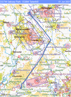
Outboudn route from Tatenhill to Oaksey PArk Airfield turning overhead Wolverhampton to travel on the west of BirminghamReturn route via daventry to the east of Birmingham


Wednesday, 28 November 2018

Flying visit on a clear, sunny day to Shobdon airfield.

At the end of October we had a nice flight down to Shobdon airfield, home of the Herefordshire Flying Club.

Planning a few days out I was supposed to be by myself, as the weather was stunning in the morning I gained a passenger.

Arriving at the airfield, I checked and readied the aircraft then had a quick break before pulling her out of the hanger, taxying and departing Tatenhill. Making sure to make a phone call first to Shobdon as they require Prior Permission before landing there.

The flight to Shobdon was fairly smooth at 2500ft below some cumulus clouds. I contacted Shawbury and obtained a basic service from them and routed between Cosford and Wolverhampton and then past the isolated Clee hill with its radome on top.

Approaching Shobdon we dropped Shawbury and called Shobdon for joining information, as they had our details it reduced some of the traffic on the radio and they were able to pass the runway in use (08 - Right hand circuits). I announced my intention to do an overhead join and was reminded to not descend below 1500 feet until on the downwind leg, due to noise abatement as there is a small village to the north of the airfield. Part of the reason to hold the descent at 1500 is to allow for the gliding club climbing out of the northern grass runway.

Landing in a reasonably short distance I made the turnoff and crossed the northern grass runway. The parking for visiting aircraft was well signposted and I was also given guidance over the radio to a parking slot.

After shutting down the aircraft, and entering the buildings booking in an paying the landing fee was a swift process. The landing fee was £14 and there is a loyalty scheme for regular visitors.

The lunch menu for the day consisted mainly of fried products and we both opted for the light breakfast that was available.  The office, the cafe and a club bar area are in a nissan hut that is quite well maintained.

After refreshments I booked out and was given a short briefing on a couple of points to avoid e.g. ensure taxiing on the grass taxiway and not the grass runway, once power checks were done to keep a good lookout up the approach as there may be glider traffic on the approach to the grass runway before crossing.

The aircraft parking and taxiways are very clearly marked and so there was no issue with taxiing out.

For the return flight we passed up the west side of Clee Hill and then between RAF Cosford and Halfpenny green.

Arriving back at Tatenhill we refuelled the aircraft, cleaned the windows and parked it back in the hanger.

Shobdon is a welcoming airfield which has nice facilities, I understand that since our visit the Cafe is changing management, so we might return to visit to see how it changes.

Friday, 17 August 2018

Return from Beverley via Spurn Point

The return leg of our flight up to Beverley was folloing  more scenic route down the coast to Spurn Point before turning inland at Grimsby, as this was a weekend and the weather was good we transited over RAF Waddington at 4500ft.  One of the reasons for coming north on this trip and not south was because the weather was good and there were a number of gliding competitions to the south to avoid (as one pilot found out).

After a little time and booking out at Beverley I checked the Cessna over and manually checked the fuel tanks to see how much was left in. Happy with the aircraft we climbed in and prepared to the return journey. After the last checks just short of Beverley's Alpha old, we lined up rolled down the grass of runway 12 and in a short time were airborne, turning left we headed out of the circuit to the north until clear and set course east for the coast, before following the coast southbound, and contacting Humberside radar for a basic service.

Offshore windfarm
Looking out to sea, I pointed out that the sight of the offshore wind farm was a bit of a surreal sight. A huge area of white stalks sticking up out of the sea, as we were moving it reminded me slightly of the graphics from old computer games.

Spurn Point
As we approached the Humber Estuary I turned inland to avoid the Gas Venting station that was marked on the map, such that we passed slightly inland of Spurn point. The Humber estuary is quite a substantial body of water and it feels odd flying over it for someone who is used to normally flying overland, at least this takes some of the edge off When I decide to head to the continent at some point.

Leaving Spurn Point behind we passed to the east of Grimsby and started the turn inland towards Bardney disused airfield.

Climbing up to 4500ft, we travelled through quite smooth air up until our next turn at Bardney disused airfield.

Having confirmed with Humberside that Waddington Zone was not active the controller politely reminded me that at my altitude we could go straight over the top as long as I stayed out of their ATZ.

After shortly after passing over Waddington the controller said that I was passing outside his cover and that I should free-call East Midlands for a service off them.  I tuned into East Midlands and listened for a gap in the comms.  G-OM had just called them requesting for a 'traffic service', this is a service from a radar controller that gives information and warnings of other traffic that may affect the flight.  As soon as the controller had identified G-OM he gave him a warning of 'two contacts straight ahead 1 mile, no height' which G-OM replied, 'seen, gliders taking avoiding action'.  There then followed a couple of minutes of radio exchange between the two of them as the pilot weaved his way out from the middle of a large group of gliders with the assistance of East Midlands.

Once the airwaves settled down, both me and another aircraft contacted East Midlands to request services from them.

The rest of the flight went well, and as the route approached Tatenhill and the controlled airspace surrounding East Midlands lowered, I descended a couple of  times to keep clear. Passing over the recently disused Hucknall airfield, which is rapidly becoming a housing estate.

Arriving back at Tatenhill at 1645 I was happy to see that fuel was still available and topped up the aircraft so that the next pilot didn't have to.  Taxiing back to the hanger, cleaned the bugs off and put the aircraft to bed until its next adventure.

All in all a successful trip as we got to see a new airfield, had a nice view of the coast and some different sights. Additionally I have gained more confidence talking to air traffic and using the radio equipment in the aircraft. I look forward in the near future to either doing a transit of controlled airspace, or utilising a traffic service.

Flight Details:
Distance: 127nm
Duration: 1h 27m
Sights: Spurn Point, Humber Estuary