Translate

Showing posts with label dam. Show all posts

Sunday, 19 February 2023

Knypersley Reservior and Brown Edge 5 Mile loop

This is a walk starting at the Greenway Bank Country Park at Knypersley Reservoir following the reservoir shore and then climbing uphill through fields, then heading downhill to follow a stream through grit stone and then up to Marshes Hill Common and Brown Edge Village before returning to Knypersley along the canal feeder.

Marshes Hill 
Distance: 5.19 miles

Parking: Greenway Bank Country Park

During summer months coffee may be available in the Country Park, toilets can also be located at the start of the walk.


Knypersley Tower
Heading past the buildings and along the paths into the park, passing two gates before heading down steps that lead steeply down to the Reservoir and turning left to walk aroung the western end of the reservoir. Follow the trail all the way, past the walkway between Serpentine Pool and Knypersley Pool, until you find Knypersley Tower, here turn sharply left to follow the path uphill away from the lake.

This path leads uphill through fields until reaching a gate onto a track, turnleft along the top of the ridge and follow until just before a gate at a farmyard turn right, almost doubling back to follow a path downhill into the woods.

There is a split in the path, take the left fork and pass over a wall before descending further down a bank to cross a bridge and follow the obvious path along the stream (this is the Head of Trent) as it carves a small gorge into the gritstone.

Eventually the path arrives at a farmyard, pass to the right of the barn and through a gate into the yard. Head straight up the access road and cross the public road into the field opposite, follow the short climb onto the ridge over the road and continue straight ahead.  After some houses the path arrives at Marshes Hill Common where the path splits as it passes through the common to the carpark at the south end, follow the access road into Brown Edge Village and continue straight onto Back Lane before picking up a path on the right just before the radio mast.

Brown Edge

Follow this down until it meets with the Roads and turn left onto New Lane ot head down towards the Church. Keep heading down through the village until Stonehouse Lane where we turn left and follow the lane for a short distance before turning left onto a path which takes us downhill to the canal feeder and Tongue Lane, cross the Lane and follow the path along the Canal Feeder all the way to the Dam. there are quite steep steps up onto the dam.

When we last did this walk we followed the road back to Greenway Bank Country park, but there are also trails following the reservoir back to the car park.

We liked this walk as it was varied, had some good views from the park and gave us a few surprises along the way.


Ordnance Survey Route: Route - Knypersley and Brown Edge


Sunday, 7 March 2021

Bosley Reservoir - a surprising find.

Bosley Reservoir taken from the SW corner with Croker Hill and Bosley Minn in the background the reservoir is flat calm with Canadian Geese floating in the middle.


We have driven past Bosley Reservoir on numerous occasions heading towards Derbyshire and Buxton, although never stopped having normally headed off to Rudyard, Tittesworth and some of the other better known reservoirs in the area.

Last year, having got bored of the local walks from the house we started looking for local walks that would be quiet and decided to have a drive round to see if we could find anywhere to park near Bosley and see if we could park and enjoy a walk.

Following the single track road that heads around the eastern side of the reservoir, near the dam is a small patch of roadside parking for around 8-10 cars. Parking hear you can either climb over a small wall and pass through a gate onto the dam and head towards the western side of the water, or walk 20 yards up the road and pass through another gate to get access to the eastern bank.

A couple of important notes:

At the northern end the reservoir goes right up to the main A54 road and to complete a full lap of the reservoir includes walking 300 metres on this road as it twists down the hill, with extremely narrow verges so take extreme care. The western entrance to the A54 is on Folds road, the eastern entrance is a style over the crash barrier at the side of the A54.

During the warmer months cows graze on the grass on the western bank, so be prepared for this, we have seen them blocking the narrower paths that are close to the A54.

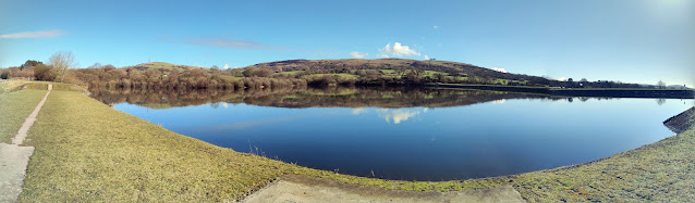
Panorama showing a flat calm reservoir with clear blue skies, some water birds on the reservoir.
From the parking area to get to the western bank you walk along the dam bank and over a small bridge across the spillway to a small kissing gate that leads to tree lined pasture. The level of the water changes dramatically throughout the year and this is more visible on the western side as the level recedes revealing extra land.

Continuing round eventually the reservoir gets closer to the edge of the public area and the path narrows to thin path on top of the bank, through a wooded area until eventually the path arrives at Fold lane and a style where you need to decide whether to continue onto the A54 or turn and retrace your steps back to the car.

The eastern bank differs from the west side as the sides of the reservoir are steeper and the path sticks closer to the side of the water and is roughly 10-15 feet above the surface, also the angling club occupies this bank with lots of fishing points below the path. The first part of the path is gravelled although later on it decays into a muddy path, which require adequate footwear for muddy paths in winter, when reaching the angler's car park you need to use the style next to the car park gate and walk a short distance up the single track road until you find a gate on the left through which you can regain the track back along the reservoir.

The trail continues through the trees until it arrives at a rise that ends at the style over the crash barrier onto the A54, again this is the point to decide whether to turn left onto the A54 and continue to do the full lap or retrace your steps back to the car. Turning right onto the A54, about 30 meters further up on the left is a track that leads up onto Croker Hill.

Bosley reservoir is a haven for bird life, whether water based or small birds within the woods.

Some of the birds we have seen here are: Blue Tits, Robins, Geese, Tufted Ducks and Grebes along with many more. The banks have many different habitats as you walk around.

The complete lap of Bosley reservoir is 2.96 miles walking an out and return on the western bank should be of the same length.