Translate

Showing posts with label bosley. Show all posts

Sunday, 5 March 2023

Bosley walk to Hawkslee and abandoned Mareknowles farm


This is a walk over Bosley Minn starting at the Bosley reservoir Dam.

Start Point: Bosley Dam where there is parking for around 8-10 cars.

Refreshments: Nil😒

This walk is over Bosley Minn and down into the valley on the far side, past Mareknowles Abandoned farm, in April the southern slopes by the farm may be covered in wild daffodils. We have been told that before the farm was abandoned the two daughters used to hike weekly across to the Macclesfield road, hitch into Macclesfield and then get the bus back to Bosley with their shopping before carrying it back to the farm. This is mostly on farm tracks, and across fields. The eastern part of the walk into the valley is along steep slopes into the valley and can get a bit hard to follow, there may be cattle in the fields before the climb back out of the valley, which is up a fairly short but extremely steep, this is a challenging

Bosley Reservoir from Bosley Minn
Leaving the car at the Dam, head down the road until the bend at the bottom, and then turn left up the private road towards Minshull, before arriving at the buildings the path is directed off the road to head along a footpath through a garden before rejoining the main track through the rest of the farm buildings. Continue uphill through gates, this part does have some surface mud from the farm and you may be escorted by the quite friendly dogs.


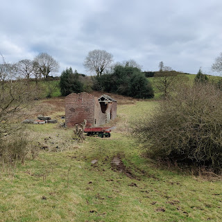
Mareknowles Farm
As the track crests a small rise the path drops straight ahead to a bridge in the gully stepping off the bridge and heading up to the next gate is regularly muddy so choose your path carefully, after the next gate it dries out, and follow the tree line up to the fields, through a gate and then turn left at the next gate (with signposts), follow the path along the side of the hill all the way as it bend s left and then arrives at a gate, a seat with a view and the road. Turn left on the road and continue up hill until there is a footpath sign on pointing right. I prefer to pass this and turn onto the track another 20 yards further up, but the path will cut the corner).

Follow the track all the way downhill until you reach the Abandoned Farm at Mareknowles. If you are lucky in Spring the slope to the right may be filled with daffodils. 


Once you have taken in the sight of the abandoned buildings pass through the kissing gate and follow the path along the edge of the slope until there is a gate on the right with a waymark, turn right here and again follow the path along the top of the slope above the brook (there is another path about 5 feet below this one running parallel. when the path opens onto a fern covered field, try to head across following the waymarks, if the ferns are up try to head straight ahead and to the left until the path starts going down into woodland. I like this woodland as it is very quite and just about every tree shows the signs of a difficult life.

At the end of the woodland there is a bridge that takes us into the field, climb up into the field, but not too far as we need to keep to the bottom and head back down to another bridge which takes us back across the brook to the path leading up a very steep slope to a kissing gate at the top. this kissing gate opens into fields, stay right until the third field where we are looking to exit the field to follow the path to the left of the farm, follow the way marks and diversion (where the track heads right head up the paths)

This path winds round until it meets Minn-End Lane at Hawkslee, head straight over the lane to a style and follow the path round the back of the buildings to another style and then straight along the field to the footpath sign where we head diagonally across to the corner.

Continue out of the field through some mud (over decking and into fields beyond). In the next field is where we turned to head around the hill, head back to Bosley dam via the same route that came up the hill.

This is a lovely walk that is often very quiet once you are on the eastern side of Bosley Minn, although this particular one can be challenging.


Sunday, 24 April 2022

Bosley Reservoir from Bosley Locks


This is the final walk of three from Bosley locks. This loop takes in a walk along the canal, around the hills to the east and then returning via Bosley Reservoir. The walk passes up the hills with some views west to Cheshire.

Distance 7.5 miles, climbing 650 feet.
One busy road to cross twice and another busy road to walk along, cows may be in fields along the route. 

The two other walks from Bosley Locks are:

From Bosley locks had north along the canal for 2 miles until the swing bridge at Oakgrove were we cross the canal (footbridge also available), cross the main road and continue up the side road ahead, when this gets to the entrance to Hawkshead Quarry turn right and head up the track.

Swing Bridge across the canal, footbridge can be seen to the right of shot.
Oakgrove Swing Bridge (footbridge to the right)

Disused bridge.
Follow this until it forks, taking the left track until arriving at a duck pond. Follow the track off to the left which takes you along a ditch. Follow this ditch it will pass an old disused stone bridge before meeting a stream with bridges, continue ahead after a while. Eventually the path turns away from the stream and heads uphill after a while the path turns sharply left onto a small foot path uphill until it arrives at a gate turn left after the gate and follow this track until a T junction with a track where we turn left. 

This track takes us to another gate on the left just before a T junction head through the gate and follow the track up the hill, after a short distance a footpath sign points to the right, follow this across the field.

This path takes us along the edges of fields until a line of trees where we turn left going uphill again to a farm track where we turn right, follow this to Upton Fold Farm. Turn left to head downhill, first through fields and then along a distinct concrete farm track.

Shortly after passing through a gate the path enters woodland on the left, and over a short bridge, head diagonally right on entering the field to join a track leading up the far bank, this track takes you down hill passing a derelict barn surrounded by fencing.

Walk all the way downhill to the road, carefully cross the road (it is a fairly busy, windy road) and walk along the road, after a short distance you can take the style on the left to head down the east shore of Bosley Reservoir, and walk around the reservoir and rejoin the route before heading back towards the Locks. However for the main walk continue on down the road until the junction at the bottom of the hill.
View of Croker hill.

Turn right onto Brooks Lane, a short distance after the garage on the left there is a style cross over this and head up the slope, pick up the tree line, saying to the right, after a dip follow the left edge of the field up the slope and continue until a farm, heading straight ahead along the track.

At the junction turn left onto Stoneyfold Lane which takes us down to the A523, turn left and then right into Bull Gate lane to return to Bosley Locks and the Parking.


Sunday, 6 March 2022

Bosley Locks 'Balloon' walk along the Macclesfield Canal

This is the first of 3 walks starting at the Bosley Lock Boater's Facility walking along the Macclesfield Canal.

Link to OS Maps route.

Bosley Locks is a flight of 12 Locks located near Bosley, South of Macclesfield. 


There is a small roadside parking area at the northern end of the twelve (Lock 1), from here you can walk south past all twelve locks, but the walks I describe start at lock 1 and head away from the lock flight norhwards. The towpath can be joined by either crossing the road bridge and turning right through a gate, or when the facility vehicle gate is open using this and crossing over a small footbridge. On weekdays the 109 bus between Leek and Macclesfield passes on the A523 1KM to the east, please check to see if it stops at the conquest plants nursery stop.

This is an easy 5.8 mile walk along the towpath and some minor and quiet roads. There are a few steps off the road to rejoin the canal. For a 7.5 mile circular walk to Gawsworth try Bosley Locks, North Rode and Gawsworth, if you want to head around some of the local hills try the thired walk out to Bosley Reservoir

Follow the Canal Towpath north from the boaters facility passing fields, which often have geese and other birds in them, there are unfortunately only two seats on this walk, the first shortly after setting off and the second just before the swing bridge where you leave the canal.

Continue alongside the canal as it transitions from fields to a wooded terrace on the side of a hill with farmland sloping off to the left. As the cutting on the right descends to meet the canal level there is a gate, beyond which is the Oakgrove swing bridge, pass through the gate and turn left to descend down Woodhouse End Road. Follow this road, until you come to the railway bridge and just after this turn left to follow Cowbrook Lane.

The Lane crosses back across the railway before descending past a farm and climing back up until it reaches the canal where you rejoin and head south back to the Boaters facility.


Saturday, 3 April 2021

Bosley Reservoir, Croker Hill and Bosley Minn


Croker Hill looking North Towards Shutlingsloe


A 6.5 walk from Bosley reservoir with some uphill is this walk over up the nearby Croker Hill onto Sutton Common and then back along the ridge between Wincle Minn and Bosley Minn.

Mostly on Tracks, some mud in wet weather, including passing around the reservoir.
Livestock may be present in some fields.
There are some good views out across the Cheshire Plain and north and East towards the Peak district.
Parking is on the roadside by the Bosley Reservoir dam.
There are no pubs on this walk.


Parking by the reservoir dam, walk past the first gate onto the dam and continue up the road to the second gate, then walk along the reservoir bank, passing onto the single track road at the fishing club car park and then back onto the reservoir path at the next gate, and continue until the path climbs up to the style onto the main road. Turn right onto the main road and walk the 100 or so metres up the road until you find the signposted track off to the left.

Derelict farm building
Follow the track up the hill, all the way past a derelict building on the right then after another couple of turns the track slopes down slightly before a right hand bend the signposted path heads across the field to the top corner and a style that leads through a small wood, a bridge and more styles, at the far side find another track and turn right on this to continue uphill following the obvious track.

With the farm above on the right the path separates from the track before a gap between fields, the style is to the right of the gap, passing over this style, the path heads right to another style and towards the farm. There is a marked diversion heading across the field to another style to avoid 'friendly but boisterous' dogs. At the next style head up the road and follow this onto the hill, good views are available from the top of the hill, continue past the radio mast until the path on the left through the farmyard.

Follow this path downhill to the main road where you turn left for a short distance before finding the track on the right heading uphill, this track becomes a road and continues along the length of the ridge.

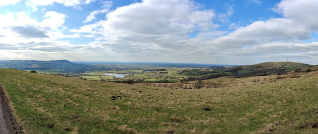
West from the ridgeline, Bosley Cloud to the left, with Bosley Reservoir and Croker hill on the right.

 As the road descends there is a seat with a footpath sign on the right, this is the first of a few paths that head off the Minn heading for the path that heads down the hill, a couple of other paths further on the road also meet this path, choose one and then follow these downhill, through a farmyard and back onto the single track road by Bosley Reservoir, turn right and return to the car.
Muddiest part of the walk.

Sunday, 7 March 2021

Bosley Reservoir - a surprising find.

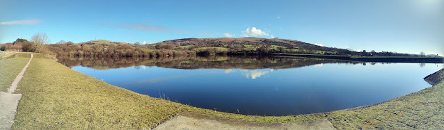
Bosley Reservoir taken from the SW corner with Croker Hill and Bosley Minn in the background the reservoir is flat calm with Canadian Geese floating in the middle.


We have driven past Bosley Reservoir on numerous occasions heading towards Derbyshire and Buxton, although never stopped having normally headed off to Rudyard, Tittesworth and some of the other better known reservoirs in the area.

Last year, having got bored of the local walks from the house we started looking for local walks that would be quiet and decided to have a drive round to see if we could find anywhere to park near Bosley and see if we could park and enjoy a walk.

Following the single track road that heads around the eastern side of the reservoir, near the dam is a small patch of roadside parking for around 8-10 cars. Parking hear you can either climb over a small wall and pass through a gate onto the dam and head towards the western side of the water, or walk 20 yards up the road and pass through another gate to get access to the eastern bank.

A couple of important notes:

At the northern end the reservoir goes right up to the main A54 road and to complete a full lap of the reservoir includes walking 300 metres on this road as it twists down the hill, with extremely narrow verges so take extreme care. The western entrance to the A54 is on Folds road, the eastern entrance is a style over the crash barrier at the side of the A54.

During the warmer months cows graze on the grass on the western bank, so be prepared for this, we have seen them blocking the narrower paths that are close to the A54.

Panorama showing a flat calm reservoir with clear blue skies, some water birds on the reservoir.
From the parking area to get to the western bank you walk along the dam bank and over a small bridge across the spillway to a small kissing gate that leads to tree lined pasture. The level of the water changes dramatically throughout the year and this is more visible on the western side as the level recedes revealing extra land.

Continuing round eventually the reservoir gets closer to the edge of the public area and the path narrows to thin path on top of the bank, through a wooded area until eventually the path arrives at Fold lane and a style where you need to decide whether to continue onto the A54 or turn and retrace your steps back to the car.

The eastern bank differs from the west side as the sides of the reservoir are steeper and the path sticks closer to the side of the water and is roughly 10-15 feet above the surface, also the angling club occupies this bank with lots of fishing points below the path. The first part of the path is gravelled although later on it decays into a muddy path, which require adequate footwear for muddy paths in winter, when reaching the angler's car park you need to use the style next to the car park gate and walk a short distance up the single track road until you find a gate on the left through which you can regain the track back along the reservoir.

The trail continues through the trees until it arrives at a rise that ends at the style over the crash barrier onto the A54, again this is the point to decide whether to turn left onto the A54 and continue to do the full lap or retrace your steps back to the car. Turning right onto the A54, about 30 meters further up on the left is a track that leads up onto Croker Hill.

Bosley reservoir is a haven for bird life, whether water based or small birds within the woods.

Some of the birds we have seen here are: Blue Tits, Robins, Geese, Tufted Ducks and Grebes along with many more. The banks have many different habitats as you walk around.

The complete lap of Bosley reservoir is 2.96 miles walking an out and return on the western bank should be of the same length.


Wednesday, 27 September 2017

Walk over The Bosley Cloud

Wanting a short, but slightly strenuous walk today, we decided to follow a walk that appeared in the walking guide 100 Walks in Cheshire by David Bishop (Route no. 52).

Near the start of the walk, Timbers Brook.

The route was easy to follow as it stayed on well developed paths, although we did decide to come of the route as the road that this follows was a bit busier than we would have liked.  There were a couple of times that we had to think about the directions on after we had reached the summit and were on our way down, but checking the map in and a bit of thought showed us the right way.

Panorama near the top.
Even though the weather was hazy, from the summit we could just about make out the radio telescope at Jodrell bank, which according to the sign by the trig point was 8 miles away as well as some of the larger buildings in Macclesfield and would look forward to popping up here again when the weather is clearer.

The walk starts off on an open track and heads through woodland most of the way to the summit.  Pausing at the first clearing that had a view we took advantage of the low seat that was there and had lunch.


As we approached the summit it cleared to open moorland where the best views are to be had in all directions, including a view down towards Rudyard lake.

By the trig point there is a metal plaque pointing out directions and distances to some of the local landmarks, but it is probably optimistic to say you can see London.

The Bridestones.
The walk downhill is also pleasant passing down steps and through more woodland down to the main road, here we walked the short distance to visit The Bridestones, which is the remains of a burial mound, the stones being those that surrounded the burial chamber itself.

Turning to the road we started walking towards the coach and horses, but gave up on this as it stayed to get into tight bends so we checked the map and found a small footpath that cut a corner back to one of the lanes that lead back to the car park.

Overall this was a nice walk, not too strenuous and with great views and a nice variety of terrain and landscape to walk through.


The directions in the guide were reasonably easy to follow and lead us on our way quite well.