Translate

Saturday, 3 April 2021

Bosley Reservoir, Croker Hill and Bosley Minn


Croker Hill looking North Towards Shutlingsloe


A 6.5 walk from Bosley reservoir with some uphill is this walk over up the nearby Croker Hill onto Sutton Common and then back along the ridge between Wincle Minn and Bosley Minn.

Mostly on Tracks, some mud in wet weather, including passing around the reservoir.
Livestock may be present in some fields.
There are some good views out across the Cheshire Plain and north and East towards the Peak district.
Parking is on the roadside by the Bosley Reservoir dam.
There are no pubs on this walk.


Parking by the reservoir dam, walk past the first gate onto the dam and continue up the road to the second gate, then walk along the reservoir bank, passing onto the single track road at the fishing club car park and then back onto the reservoir path at the next gate, and continue until the path climbs up to the style onto the main road. Turn right onto the main road and walk the 100 or so metres up the road until you find the signposted track off to the left.
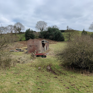
Derelict farm building
Follow the track up the hill, all the way past a derelict building on the right then after another couple of turns the track slopes down slightly before a right hand bend the signposted path heads across the field to the top corner and a style that leads through a small wood, a bridge and more styles, at the far side find another track and turn right on this to continue uphill following the obvious track.

With the farm above on the right the path separates from the track before a gap between fields, the style is to the right of the gap, passing over this style, the path heads right to another style and towards the farm. There is a marked diversion heading across the field to another style to avoid 'friendly but boisterous' dogs. At the next style head up the road and follow this onto the hill, good views are available from the top of the hill, continue past the radio mast until the path on the left through the farmyard.

Follow this path downhill to the main road where you turn left for a short distance before finding the track on the right heading uphill, this track becomes a road and continues along the length of the ridge.
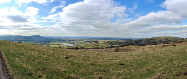
West from the ridgeline, Bosley Cloud to the left, with Bosley Reservoir and Croker hill on the right.

 As the road descends there is a seat with a footpath sign on the right, this is the first of a few paths that head off the Minn heading for the path that heads down the hill, a couple of other paths further on the road also meet this path, choose one and then follow these downhill, through a farmyard and back onto the single track road by Bosley Reservoir, turn right and return to the car.
Muddiest part of the walk.

Sunday, 7 March 2021

Bosley Reservoir - a surprising find.

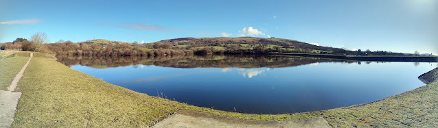
Bosley Reservoir taken from the SW corner with Croker Hill and Bosley Minn in the background the reservoir is flat calm with Canadian Geese floating in the middle.


We have driven past Bosley Reservoir on numerous occasions heading towards Derbyshire and Buxton, although never stopped having normally headed off to Rudyard, Tittesworth and some of the other better known reservoirs in the area.

Last year, having got bored of the local walks from the house we started looking for local walks that would be quiet and decided to have a drive round to see if we could find anywhere to park near Bosley and see if we could park and enjoy a walk.

Following the single track road that heads around the eastern side of the reservoir, near the dam is a small patch of roadside parking for around 8-10 cars. Parking hear you can either climb over a small wall and pass through a gate onto the dam and head towards the western side of the water, or walk 20 yards up the road and pass through another gate to get access to the eastern bank.

A couple of important notes:

At the northern end the reservoir goes right up to the main A54 road and to complete a full lap of the reservoir includes walking 300 metres on this road as it twists down the hill, with extremely narrow verges so take extreme care. The western entrance to the A54 is on Folds road, the eastern entrance is a style over the crash barrier at the side of the A54.

During the warmer months cows graze on the grass on the western bank, so be prepared for this, we have seen them blocking the narrower paths that are close to the A54.

Panorama showing a flat calm reservoir with clear blue skies, some water birds on the reservoir.
From the parking area to get to the western bank you walk along the dam bank and over a small bridge across the spillway to a small kissing gate that leads to tree lined pasture. The level of the water changes dramatically throughout the year and this is more visible on the western side as the level recedes revealing extra land.

Continuing round eventually the reservoir gets closer to the edge of the public area and the path narrows to thin path on top of the bank, through a wooded area until eventually the path arrives at Fold lane and a style where you need to decide whether to continue onto the A54 or turn and retrace your steps back to the car.

The eastern bank differs from the west side as the sides of the reservoir are steeper and the path sticks closer to the side of the water and is roughly 10-15 feet above the surface, also the angling club occupies this bank with lots of fishing points below the path. The first part of the path is gravelled although later on it decays into a muddy path, which require adequate footwear for muddy paths in winter, when reaching the angler's car park you need to use the style next to the car park gate and walk a short distance up the single track road until you find a gate on the left through which you can regain the track back along the reservoir.

The trail continues through the trees until it arrives at a rise that ends at the style over the crash barrier onto the A54, again this is the point to decide whether to turn left onto the A54 and continue to do the full lap or retrace your steps back to the car. Turning right onto the A54, about 30 meters further up on the left is a track that leads up onto Croker Hill.

Bosley reservoir is a haven for bird life, whether water based or small birds within the woods.

Some of the birds we have seen here are: Blue Tits, Robins, Geese, Tufted Ducks and Grebes along with many more. The banks have many different habitats as you walk around.

The complete lap of Bosley reservoir is 2.96 miles walking an out and return on the western bank should be of the same length.


Thursday, 14 May 2020

Book Review: Operators Handbook

Having had for years a copy of the Red Team Field Manual (RTFM), and the Blue Team Handbook: Incident Response Edition, I recently came across a more up to date book Operator Handbook, subtitled SEARCH.COPY.PASTE.L33T;). Additionally there is a Blueteam Field Manual (BTFM) which I have not bought.

A quick background on the RTFM, BTGM and Blue Team Handbooks, these were designed as references for the respective Cyber Security teams, the RTFM being targeted at Penetration Testers and the BTFM and Blue Team Handbook being for the Cyber defenders. The books differ slightly in their approach the Field Manuals being more the form of cheat sheets with lists of commands and tables of useful data e.g. if you want to run NMAP on a target you would go to the NMAP page and all the flags available for NMAP are listed to aid in its use along with a couple of examples and this requires some previous knowledge of the tools. Blue Team Handbook is more narrative and explanatory in nature giving simple but introductory information about processes and descriptions of tools. Also the Operators Handbook is aimed at Pen Testers and Cyber Defenders and would assist other IT professions.

The first thing you notice about the Handbook is the size, compared to the RTFM this is a fairly chunky handbook.

Operators Handbook, Blue Team Handbook and RTFM.


The Operators Handbook follows a similar pattern to R& BTFMs in that the information is mostly tables of data and cheat sheets. There are a limited number of explanatory texts, one of the more detailed is under the OSINT section which breaks down into small explanatory texts before changing back to the lists.

For me an improvement over the predecessors is that all the tools are listed in alphabetical order, the RTFM broke them down into subject areas such as *nix, Networking and Tips and Tricks, so for me this was just a little too inconvenient to locate the information. The Operator Handbook however, if you are interested in Jenkins Exploits then you can head straight there.

At the start of each tools section is a line which indicates who the tool is for, What type of tool it is, and the operating system or service it relates to, under the section for MIMIKATZ this line tells us its for RED TEAM, is for ESCALATE PRIV and is WINDOWS based, and then follows with a quick two line introduction to the tool and then starts listing the useful commands and lists. The last few of the 436 pages are space for your own notes so you can add anything you need at this point.  

There is an impressive list of tools and techniques within this Handbook, although I did find a few things that we use that were absent. This would be exceptionally useful to have at your fingertips when you need a refresher for those tools that you just don't use that often, or to quickly check something whilst you are learning a new system. The book weighs in at 693 grams and would require consideration before putting in your pack and carrying around every day. 

I'm happy with my purchase and will keep this copy to hand, probably moving this to work, for the price I might purchase the Kindle version to avoid the volume an wight in my backpack on public transport. This would be a handy reference guide for anyone starting life as either a Pen Tester or in a more defensive Cyber-Security role.

As well as the Paperback copy selling for £11.76 there is a Kindle Version for £8.08, the copy I have is V1 which was released on 02 APR 2020

Saturday, 18 April 2020

Hill walk starting at Rhewl, near Lllangollen, North Wales


Distance: 5 miles

Start point: The Sun Inn Rhewl, park in the car park, refreshments available from 1700.

Walking: mostly paths, trails or quiet roads, though there are a few difficult areas including a steep slope.


In October last year we popped to North Wales for the day visiting the small town of Mold where we search the local shops for a local walking book. not finding one for the local area, we did find one we liked based in the Llangollen area. Kittiwake walks around Llangollen & the Dee Valley (David Barry)

Driving over the Horseshoe Pass we headed up a side road to The Sun Inn, Rhewl and the start of Walk 17 (Foothills of Moel Morfydd). The Inn allows cars to park in the car park whilst going on walks, although it is suggested that you pop in for a drink when you have finished the walk.

Heading out of the car park down the road you get to walk alongside the side of the River Dee for a short while before heading up into the hills. After a short climb you get a good view along the valley back to Rhewl, before passing over the ridge into the next valley and down again along some roads before heading across a small ford and back onto the main trail. In the guide there it tells you to leave the fence at a second gate and head off at an angle down the hill, do follow the guide, but not too literally at this point as the gate to exit the field is higher up than you would think.

There is a possibility on this hillside to see steam trains travelling along the Dee Valley line. Although there was no steam trains whilst we were there the line of the track was highlighted by a couple of passing Diesel engines.


Following the trail according to the guide book takes you to a disused farm house and then just down from the house a barn (point 3 in the guide), with a number of fences. The guide tells you that at the left of the barn there is a style to climb over before heading up a trail into the hills. Unfortunately the fence and style appear to have deteriorated and been replaced by a gate across the path, although not impassable, the rough ground that it stands in makes it better to head back down to the main path, pass through the gates and walk up the rear of the barn.

Taking care to follow the guide, the next 50 yards are the hardest part of the walk, heading up a steep slope through some trees to the right of a stream, the trail is indistinct and this seems out of place considering the good paths that make up the rest of this walk. I paused a few times wondering if we were heading in the right direction, but as you reach the end of the trees the footpath that you are heading for appears and it starts to make sense again. Although shortly after this the path again disappears but keep following the fence up the hill before the paths become proper trails again.

Shortly after passing point 4 and at the base of the slope, take care if the ferns are tall. As you arrive at the next fence there is a style that you climb over and then shortly after turn and follow the trail on your left rather than heading up the slope.  When we visited the ferns were still up at shoulder height and this completely hid the path other than a small path trodden down through the ferns, I could just see above the ferns, but much shorter that me and all you can see is ferns. Basically head along the slope to meet up with the right edge of the trees in the distance where the path starts to reappear.

After heading down the trails past a cottage we appeared out onto a road with a cottage, the owner of the cottage was out working in his garden and directed us to head through the gate and then down some steps to a path. Following this guidance led us off the trail in the guide and we had to find our own way backto Rhewl. A quick check of the map and we headed straight down into the valley and walked back up the road alongside the Rider Dee to the Sun Inn and the car.

Overall we did enjoy this walk apart from the steep hill by the barn that just takes you the 50 yards to get back on the trail. There were some fantastic views, especially as the trees were starting to chagne into their autumn colours. At times we were expecting rain, but the weather, although cloudy and windy held out for us.

The walking was mostly on good paths, tracks or quiet roads, the route did go up and down quite a bit, though there was a good bit of downhill towards the end. 

We found the guide book quite well laid out, with easy to follow instructions, the parts were we had problems following was more down to the changing environment and reading the detail in the instructions lead us in the right direction.