After a bit of research we settled on the island of Papa Westray and booked a flight on the Tuesday 0930 departure from Kirkwall, arriving at Papa Westray at around 10, the return flight would be the 1654 flight from Papa Westray, giving us a good 6 hours to do some walking on the Island.
 Heading south from the airfield on the main island road we headed, past the war memorial to Holland's Farm, which occupies the main crossroads on the island and includes some old buildings. The road turns right then left through the farm and there is a signpost for the Knap of Howar which we follow passing through some gates and onto a track leading towards the coast. The track ends at a field, diagonally across which there is a fenced off area with well cut grass signs identify this as our first stop, the Knap of Howar, which is one of the oldest still standing buildings, probably pre-dating the more famous settlement of Skara Brae.
 After viewing the remains we exited the fenced off area and turned north along the coast with the distant St Boniface Kirk as our next stop pausing on the way to drink some of the coffee from our flask. The ground was rough pasture, lumpy but not too hard although the wind was a fairly brisk northly.
 Along the coast the headland is lined by large formations of slab like rock sloping out of the sea. The occasional cairn marks the edge of the cliffs and the inland slopes up to small hills with a small lookout hut perched atop. Gulls and other seabirds soar the edge of the rocks and swoop low overhead.
 Before exiting the reserve we passed over a style and the arrived at a monument to the last Great Auk living in the UK.

Looking at the guide books highlighted some interesting places to visit in Papay, both historical and Natural.
Departing from Kirkwall airport a little surprise was the flight would land at Westray before Papa Westray and give us the opportunity to travel on the shortest commercial flight from Westray to Papa Westray (1.7 miles). The short stop at Westray allowed 2 of the 8 passengers to get off and be replaced by 2 more passengers.
Arriving at the small Papa Westray Airfield, we departed the flight and the airfield, took a short look around and started on the walk.


The coast field narrows as the surrounding wall approaches the coast, but we continued on until a stile and a gate just before the Kirk. We took a look at some of the gravestones before entering the restored church and reading about the history from the small board inside.
Leaving the Kirk we headed up the track to rejoin the main island road and turned left to head north. The road runs mostly straight and uphill towards North Hill RSPB reserve, the entrance is just as the road bends to the right.
Opening the gate we headed followed the stone wall to the coast crossing a couple of demolished walls and again turned northwards towards the tip of the island. The reserve itself is fairly barren heather with the occasional flower, which we imagine would be busy with breeding birds earlier in the year.

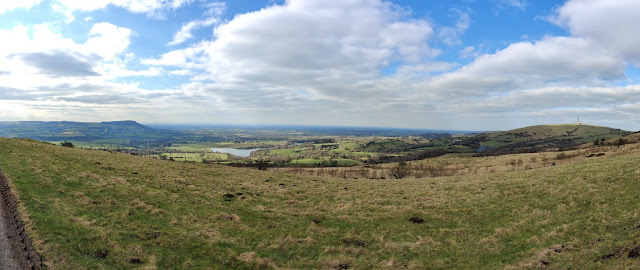
Following the coastal path up to the very north of the island looking behind us I could not see anyone following and as we rounded the north tip of the islands and looked at the rock formations I commented we could be over a mile from the next nearest person. As we started south we found a sheltered spot and stopped for lunch watching the seals bobbing just out to sea. Off in the distance we could see the only other person out for a walk, coming north towards us but then turning back to stay ahead of us. Whereas the west coast sloped down into the sea, the east coast is more cliff like, although it doesn't rise more than 200' above the sea.

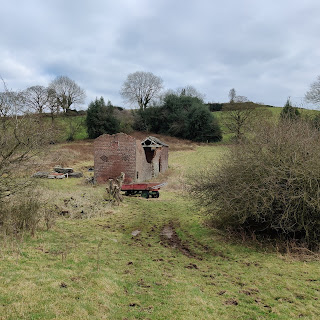
Exiting the reserve we descended back down to the coastal path and passed through some long derelict buildings, using these to shelter whilst we finished off the coffee before arriving at the tidal Loch of the Taing an area of water separated from the sea by low lying rocks at the northern end of a sandy bay.
As the tide was out we walked along the beach and listened to the water lapping against the edge of the bay at the end of which we headed up the bank to the road heading south until, just by a seat and a cairn it becomes a track. Resting on 'Maggies Seat', which overlooks another sandy bay we rested for some time.

Continuing along the track lead us to the old pier of Papay, where the Kelp Store Heritage, Art & Craft Centre is located, unfortunately the day we visited the Kelp store was closed due to exhibition preparation.
Turning away from the coast we headed up the road, again towards Holland's Farm past the main settlement, including the school, the post office, store and hostel. Just after the school is a small public convenience.
Arriving at the cross roads in Holland's farm at 1510 we decided we had some time to walk further south and followed the road for a short 1km out and return to kill off some time before the return flight, arriving at the airfield at 1600 to rest and relax before the return flight.
Checking the GPS we discovered we had walked a total of 10 miles.
The return to Kirkwall also stopped at Westray on the return leg.


")