Translate

Sunday, 20 June 2021

Flying and walking - Oaksey Park


Taking a Tuesday off from work we again looked to combine flying and walking, originally we had attempted to fly to Llanbedr, where there is a nature reserve between the airfield and the coast, unfortunately we could not arrange PPR at Llanbedr in time and so looked for an airfield that was in a nice location with footpaths nearby.


Having had a look around we found Oaksey Park airfield in the Cotswolds and planned both the flight and a walk in the local area.


An early departure for us saw a pleasant relaxed flight down to the west of Birmingham’s Zone and avoiding Kemble airfield, located just to the North of Oaksey Park we joined downwind for runway 04.


After arriving we booked in, paid our landing fees and changed into our walking shoes.


The walk away from the airfield follows the farm lane through an avenue of trees and well cut lawn. 


About 150 meters past the gates to Park Farm take the footpath on the right, across a field, turning slightly left in the next field to cross this at an angle, into the next field turn right and head along the fence continuing once the fence turns sharply right. Cross the next field and then turn left to follow the field boundary towards the village church.


Once past the church turn left and follow the road, just before the Post Office a lane comes off to the right and there is a small public garden/play area at this junction. Head up this lane all the way to the end and continue straight ahead along the path along a couple of field edges.


Well Garden, Kindly donated in 1931 by Capt, & Mrs William Phipps as a playground for village children.Wiltshire Council walk marker.
The path arrives at a large gate in a deer fence, passing through this gate into the next field, which may have deer in. Head slightly right across this field, but to the left of the manor. At the far end of the field a fence cuts the field in two, you want to be on the right side of this, and before long another large gate appears in the fence. Pass through this and continue along the signposted path.


As you enter the field with the wood at the end head slightly right heading for the far right corner of the wood, on reaching the corner turn right and follow the field edge passing through the far hedge. Turn right here and follow the right side of the next fields, until you arrive at the road, which you can follow into Oaksey village where you turn right and head back to the Post Office, turning left into ‘The Green’ which heads back to the airfield.


This was a pleasant walk taking in a lovely Cotswold Village, and surprisingly a deer park. A number of the fields did have cattle in them, which fortunately for us did stay away from our path.


Oaksey Park is a wonderfully kept grass airfield with a fair amount of activity, runway 04 was smooth and well kept, with a £10 landing fee for a C172, and was welcoming both on the phone for PPR and following our arrival. Somewhere I would visit again.


For the return flight, we departed Oaksey Park's runway 04, with a slight turn to the right for noise abatement and then headed north towards Daventry to pass to the east of Birmingham's Zone.

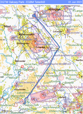
Outboudn route from Tatenhill to Oaksey PArk Airfield turning overhead Wolverhampton to travel on the west of BirminghamReturn route via daventry to the east of Birmingham


Saturday, 3 April 2021

Bosley Reservoir, Croker Hill and Bosley Minn


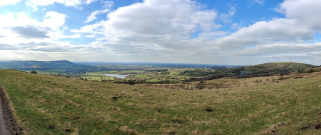
Croker Hill looking North Towards Shutlingsloe


A 6.5 walk from Bosley reservoir with some uphill is this walk over up the nearby Croker Hill onto Sutton Common and then back along the ridge between Wincle Minn and Bosley Minn.

Mostly on Tracks, some mud in wet weather, including passing around the reservoir.
Livestock may be present in some fields.
There are some good views out across the Cheshire Plain and north and East towards the Peak district.
Parking is on the roadside by the Bosley Reservoir dam.
There are no pubs on this walk.


Parking by the reservoir dam, walk past the first gate onto the dam and continue up the road to the second gate, then walk along the reservoir bank, passing onto the single track road at the fishing club car park and then back onto the reservoir path at the next gate, and continue until the path climbs up to the style onto the main road. Turn right onto the main road and walk the 100 or so metres up the road until you find the signposted track off to the left.

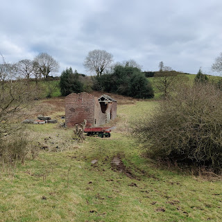
Derelict farm building
Follow the track up the hill, all the way past a derelict building on the right then after another couple of turns the track slopes down slightly before a right hand bend the signposted path heads across the field to the top corner and a style that leads through a small wood, a bridge and more styles, at the far side find another track and turn right on this to continue uphill following the obvious track.

With the farm above on the right the path separates from the track before a gap between fields, the style is to the right of the gap, passing over this style, the path heads right to another style and towards the farm. There is a marked diversion heading across the field to another style to avoid 'friendly but boisterous' dogs. At the next style head up the road and follow this onto the hill, good views are available from the top of the hill, continue past the radio mast until the path on the left through the farmyard.

Follow this path downhill to the main road where you turn left for a short distance before finding the track on the right heading uphill, this track becomes a road and continues along the length of the ridge.

West from the ridgeline, Bosley Cloud to the left, with Bosley Reservoir and Croker hill on the right.

 As the road descends there is a seat with a footpath sign on the right, this is the first of a few paths that head off the Minn heading for the path that heads down the hill, a couple of other paths further on the road also meet this path, choose one and then follow these downhill, through a farmyard and back onto the single track road by Bosley Reservoir, turn right and return to the car.
Muddiest part of the walk.

Sunday, 7 March 2021

Bosley Reservoir - a surprising find.

Bosley Reservoir taken from the SW corner with Croker Hill and Bosley Minn in the background the reservoir is flat calm with Canadian Geese floating in the middle.


We have driven past Bosley Reservoir on numerous occasions heading towards Derbyshire and Buxton, although never stopped having normally headed off to Rudyard, Tittesworth and some of the other better known reservoirs in the area.

Last year, having got bored of the local walks from the house we started looking for local walks that would be quiet and decided to have a drive round to see if we could find anywhere to park near Bosley and see if we could park and enjoy a walk.

Following the single track road that heads around the eastern side of the reservoir, near the dam is a small patch of roadside parking for around 8-10 cars. Parking hear you can either climb over a small wall and pass through a gate onto the dam and head towards the western side of the water, or walk 20 yards up the road and pass through another gate to get access to the eastern bank.

A couple of important notes:

At the northern end the reservoir goes right up to the main A54 road and to complete a full lap of the reservoir includes walking 300 metres on this road as it twists down the hill, with extremely narrow verges so take extreme care. The western entrance to the A54 is on Folds road, the eastern entrance is a style over the crash barrier at the side of the A54.

During the warmer months cows graze on the grass on the western bank, so be prepared for this, we have seen them blocking the narrower paths that are close to the A54.

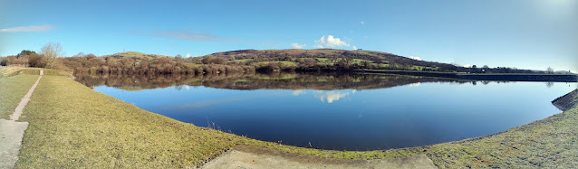
Panorama showing a flat calm reservoir with clear blue skies, some water birds on the reservoir.
From the parking area to get to the western bank you walk along the dam bank and over a small bridge across the spillway to a small kissing gate that leads to tree lined pasture. The level of the water changes dramatically throughout the year and this is more visible on the western side as the level recedes revealing extra land.

Continuing round eventually the reservoir gets closer to the edge of the public area and the path narrows to thin path on top of the bank, through a wooded area until eventually the path arrives at Fold lane and a style where you need to decide whether to continue onto the A54 or turn and retrace your steps back to the car.

The eastern bank differs from the west side as the sides of the reservoir are steeper and the path sticks closer to the side of the water and is roughly 10-15 feet above the surface, also the angling club occupies this bank with lots of fishing points below the path. The first part of the path is gravelled although later on it decays into a muddy path, which require adequate footwear for muddy paths in winter, when reaching the angler's car park you need to use the style next to the car park gate and walk a short distance up the single track road until you find a gate on the left through which you can regain the track back along the reservoir.

The trail continues through the trees until it arrives at a rise that ends at the style over the crash barrier onto the A54, again this is the point to decide whether to turn left onto the A54 and continue to do the full lap or retrace your steps back to the car. Turning right onto the A54, about 30 meters further up on the left is a track that leads up onto Croker Hill.

Bosley reservoir is a haven for bird life, whether water based or small birds within the woods.

Some of the birds we have seen here are: Blue Tits, Robins, Geese, Tufted Ducks and Grebes along with many more. The banks have many different habitats as you walk around.

The complete lap of Bosley reservoir is 2.96 miles walking an out and return on the western bank should be of the same length.


Thursday, 14 May 2020

Book Review: Operators Handbook

Having had for years a copy of the Red Team Field Manual (RTFM), and the Blue Team Handbook: Incident Response Edition, I recently came across a more up to date book Operator Handbook, subtitled SEARCH.COPY.PASTE.L33T;). Additionally there is a Blueteam Field Manual (BTFM) which I have not bought.

A quick background on the RTFM, BTGM and Blue Team Handbooks, these were designed as references for the respective Cyber Security teams, the RTFM being targeted at Penetration Testers and the BTFM and Blue Team Handbook being for the Cyber defenders. The books differ slightly in their approach the Field Manuals being more the form of cheat sheets with lists of commands and tables of useful data e.g. if you want to run NMAP on a target you would go to the NMAP page and all the flags available for NMAP are listed to aid in its use along with a couple of examples and this requires some previous knowledge of the tools. Blue Team Handbook is more narrative and explanatory in nature giving simple but introductory information about processes and descriptions of tools. Also the Operators Handbook is aimed at Pen Testers and Cyber Defenders and would assist other IT professions.

The first thing you notice about the Handbook is the size, compared to the RTFM this is a fairly chunky handbook.

Operators Handbook, Blue Team Handbook and RTFM.


The Operators Handbook follows a similar pattern to R& BTFMs in that the information is mostly tables of data and cheat sheets. There are a limited number of explanatory texts, one of the more detailed is under the OSINT section which breaks down into small explanatory texts before changing back to the lists.

For me an improvement over the predecessors is that all the tools are listed in alphabetical order, the RTFM broke them down into subject areas such as *nix, Networking and Tips and Tricks, so for me this was just a little too inconvenient to locate the information. The Operator Handbook however, if you are interested in Jenkins Exploits then you can head straight there.

At the start of each tools section is a line which indicates who the tool is for, What type of tool it is, and the operating system or service it relates to, under the section for MIMIKATZ this line tells us its for RED TEAM, is for ESCALATE PRIV and is WINDOWS based, and then follows with a quick two line introduction to the tool and then starts listing the useful commands and lists. The last few of the 436 pages are space for your own notes so you can add anything you need at this point.  

There is an impressive list of tools and techniques within this Handbook, although I did find a few things that we use that were absent. This would be exceptionally useful to have at your fingertips when you need a refresher for those tools that you just don't use that often, or to quickly check something whilst you are learning a new system. The book weighs in at 693 grams and would require consideration before putting in your pack and carrying around every day. 

I'm happy with my purchase and will keep this copy to hand, probably moving this to work, for the price I might purchase the Kindle version to avoid the volume an wight in my backpack on public transport. This would be a handy reference guide for anyone starting life as either a Pen Tester or in a more defensive Cyber-Security role.

As well as the Paperback copy selling for £11.76 there is a Kindle Version for £8.08, the copy I have is V1 which was released on 02 APR 2020